


MEET BRENT PASCUA: P.I.O FOR CAL FIRE
Brent Pascua looks a bit like Tom Cruise or Dennis Quaid or John “Turtle” Philbin depending on what angle you see him from and who’s doing the looking.
He is fond of quoting lines from Point Break: “That would be a waste of time!”

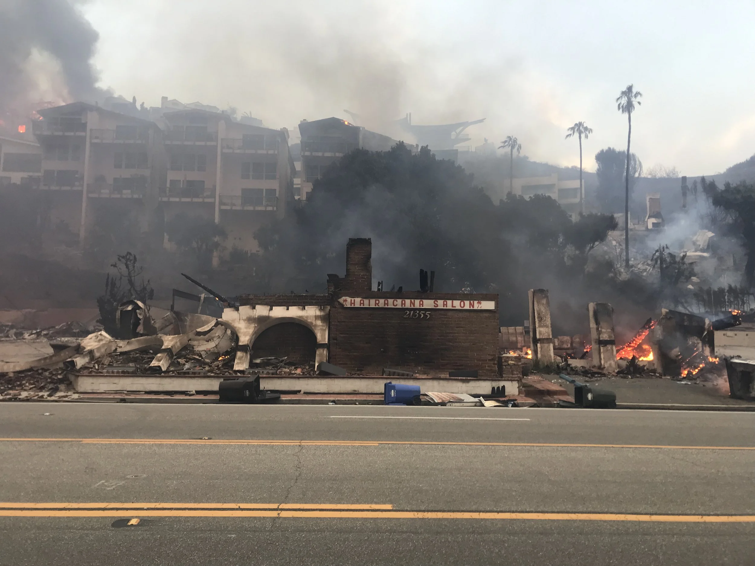
Firefighters from as far away as Texas, Washington State and the Ewok Planet showed up for this clambake. Photo: Mason Thorpe.
He started as a firefighter in San Diego, then worked his way up through engineer (driver), captain and chief before joining up with CAL FIRE in Sacramento in 2002.
In December of 2024 Brent met Point Dume residents John Hearne and Zoe Scott when he was here for the Franklin Fire (a fire in Central Malibu that - truth be told - burned a mile-plus firebreak that probably saved Central Malibu;’s bacon.)
Brent re-ignited - if you will - their acquaintance when he returned - in a hurry - for the Palisades Fire. We all met at Zinque and set up a ridealong that left Zinque around noon on Saturday the 25th.
BEGIN AT THE END: WHY THE PALISADES FIRE HAPPENED

It’s about six miles from LACO Fire Department Camp 8 to the fire source at Skull Rock Trailhead. That’s a quick couple minutes for a UH-1H Super Huey Helicopter with 324 - 360 gallons of water or a Sikorsky S-70i with 1000 gallons. If LACO resources had been engaged at the first 911 call, the fire might have been quenched before it could spread. But I guess we’ll never know.
On Sunday, February 2, just under three weeks after the Palisades Fire,I rode my bike along PCH to talk with a Particular Individual who had access to the action reports for the Palisades Fire. I was looking for a number of numbers, but one in particular: When was the first 911 call phoned in about a fire in the Palisades hills, and when did the first responders arrive on scene?
The Particular Individual had action reports for January 10 and 11 but not for the days of the fire January 8 and 9. He explained: “Los Angeles Times wanted to look at the information to do a detailed most portem on the Palisades Fire - like they did for Woolsey.”
So I went away a bit empty handed, but then on Monday morning another Particular Individual texted me a link to that Los Angeles Times reporting on Palisades, but done as a 17-minute mini-documentary that gave a timeline of the fire, but also of the pell mell evacuation that saw people abandoning their cars to get bulldozed out of the way
This is it, in vivid detail.
ESCAPE FROM THE PALISADES- AN LA TIMES MINI DOCUMENTARY.
The Second Particular Individual who sent me that link is a retired fire-fighter with 20 years of experience in the blue uniform, all over Southern California. He broke down what he thought went wrong with the response to the Palisades Fire, and why it got out of control? Essentially: LA City Fire Department tried to handle it unilaterally, and didn’t call in assets until it was way too late.
TOO LITTLE, TOO LATE: THUS ANALYZED THE 2ND PARTICULAR INDIVIDUAL

Camp 8 is only 6 miles as the
Listen to the initial 911 dispatch (10:23).
All local fire stations, no strike teams …..
The Highlands were supposed to have a fire station, City of LA never built it.
The initial engines were coming from Venice, Brentwood and the two local [LA City] stations. They didn’t even request the “closest Engines:” Malibu/Santa Monica was not on the dispatch until it was too late….
The fact that the initial Dispatch included station 63 and light force 63 (Venice) station 19 (Brentwood)means LA City did not have any strike teams staged or prepared for this historic wind event that had been forecast for days.
LA County right next-door had doubled their man power the same morning. The request for 10 engines then 20 did not request “closest engines”
LA city did not bother to ask LA County or Automatic aid. Too little too late.
Camp 8 is LA County
They were not on the dispatch
Fumbling the moment with trying to handle it with LA city resources
Truck 69 and 63 don’t even carry water or hose!
Is the city’s incompetent decision makers going to replace a community?
Too little, way Too late.
Camp 8 could be there in less than 5 minutes by air. The City didn’t bring in additional reinforcements to catch the initial fire while it was in the brush ….
And the following was the aftermath, as seen on Saturday, January 25.
ZINQUE, CHEVRON, ROADBLOCK AT COLONY HOUSE.
We rolled past the Chevron Station which was open for business, and cousin, business was boomin’ for chew and tobacco products, as all the out of town fire-fighters from Austin and Tulalip moseyed over from the Palisades Cook Off property fiending for Zins and chew.
None shall pass, without a pass. The uniforms manning the roadblock weren’t joking around. The Forbidden Zone was awash in So Cal Edison and So Cal Gas trucks, law enforcement, fire inspectors and debris removal - it was no place for civilians. Photo: Stone Parker
The road block just before Colony House Liquor was still up and manned with LACO Fire, LACO Sheriffs and some business-looking National Guard. Brent heckled and fist-bumped his way through and we entered The Forbidden Zone.

Familiar landmarks appeared, or were shockingly absent: On the right, the Octopus House marked the westernmost damage along the beach. The two busted windows and seashell nose and light fixture above two burned, snaggle-toothed garage doors gave it an alchemy of Koko the Clown, Hitler, the ticky tacky houses of Daly City and Munch’s The Scream. The look of shock and awe that many are feeling: “What happened to me? What happened to the neighborhood???!!! What will happen NEXT!!!!????”

The Octopus House at 22244 PCH and then two other burned houses, and then a large estate supposedly built by Larry Ellison for his son. From Google Maps.
THE PALISADES FIRE DAMAGE MAP = COURTESY DINS
To the east of Octopus House, there were two other houses marked Red for (Destroyed >50%) on the remarkably detailed, accurate and quickly-rendered Palisades Fire Damage Map: “That was done by the DINS,” Brent said. “The Damage INSpectors. I think there’s about 60 of them. They get it done.”
THE GOOD, THE BAD AND THE UGLY OF THE PALISADES FIRE DAMAGE MAP
Here are a few of the hundreds or maybe thousands of photos captured by the Damage INSpectors (DINS) who accounted for every house in the shadow of the Palisades Fire.


The DINS accounted for every structure in the Palisades Fire shadow, between Malibu and Santa Monica. Every structure was marked with a Monopoly-ish icon in Black (No Damage), Green (Affected 1-9%), Yellow (Minor 10-25%), Orange (Major 26 - 50%) and Red (Destroyed >50%).
Almost every structure was photographed whether it was damaged or not. An impressive organizational feat in the aftermath of chaos. I had been pouring over this map for days, looking for the homes of friends and enemies, delivering good news and bad news. Now I wanted to see it for meself.
After the Octopus house and its nuked neighbors, there was a large house, untouched, that reportedly belonged to Larry Ellison. Did he bring in private firefighters from Arizona like Rick Caruso in the Palisades?
Ellison, Caruso and other POWs (Persons Of Wealth) took some heat - so to speak - for hiring private fire-fighters to protect their properties? But is that a bad bad thing? You could argue that public defenders not defending mega-mansions frees up engines and men and women and helicopters and agencies to protect homes and property of taxpayers.
“I guess we’ll never know.”
Now this is mean but of all the houses that were marked Red, the one still standing is what some people call the Crazy Rich Persian house on the inland side of PCH - an out-of-scale shack that might be more comfortable behind landscaping in Beverly Hills and not going full frontal overlooking PCH. That place was untouched.
Verizon Building on the left, untouched, then a three-story apartment I used to rent from Janet M - when Jennifer A lived across the street and we watched her deal with her sharkerazzi during the Great Paparazzi Swarm of 2007.
JANET AND SUZY’S PLACES - BEFORE AND AFTER


Wrote a story about Malibu’s paparazzi problem 2007 here: https://malibutimes.com/article_d505a912-cc6f-58b8-9643-6a839cc63921
Next door there used to be an apartment building that is no more. That is where Suzy D evacuated her three dogs, two trucks and a Porsche - frantically, one imagines - but lost everything else. As of 1-29-25, Support Suzy to Rebuild Her Life after the Palisades Fire GoFundMe was up to $19,965, including $500 from Paris Jackson (?!) and another grand from Phil Rosenthal of Somebody Feed Phil! - a frequent visitor to Malibu Kitchen (RIP).
THE $85,000,000 PLEASURE PALACE FORMERLY KNOWN AS GEFFEN HOUSE
The Geffen house before and after. The before shot is from CaliforniaCoastline.org. The after shot is from Google Earth. Our old apartment and Suzy’s burned apartment are visible top left in the burn photo.


The very long, 4.5 miles of PCH damage begins at What Used to Be the Geffen House - a compound of several structures that David Geffen sold for $85,000,000 in 2017.
When I lived across the street and was learning to standup paddle, I would slip down the much litigated Geffen Access, launch from the beach, paddle up to First Point, noodle around and paddle back.
The Geffen House was Boo Radley empty until one night I came in to see the lights were on for the Gayest Party in the History of the World - more than 100 dudes, mostly unrobed, dancing with themselves…
…Not that there’s anything wrong with that, but it was a little shocking, almost as shocking as the entire half-acre compound reduced to - as Geffen’s protege Joni Mitchell sang: “Cause I've seen some hot hot blazes Come down to smoke and ash”
Lots of smoke and ash all along PCH beginning at the Geffen Access and all the way to Topanga - just over four miles according to Google Maps.

The AS house, unscorched except for the Guest House, with burned houses at all compass points. That house has a blue roof, which should ignite some of the Blue Roof conspiracy theorists: From Google Maps.
Doing a rough addition of that Palisades Fire Damage Map, there are roughly 400 individual lots between the Geffen Access and Topanga. Eyeballing that map, maybe two/thirds of those houses are marked Red for Destroyed. That’s a lot of smoke and ash, and where there's smoke and ash, there’s litigation, obfuscation, delays, headaches and problems.
Approaching Carbon Canyon, up to the left, a couple of torched houses, but Allen S’ house was still standing. Some say he lost his guest house, but it was easy to imagine the Ohana there in force, blasting the creeping, roaring flames with high-pressure hoses connected to their pool. AS has had enough calamity at that house.
After the Geffen house along the beach, about six torched houses and then right around where Carbon Canyon Road meets PCH, a line of unscorched houses - including Lou A’s seashell house - that might have been protected by the cliffs, or private firefighters or LACO FD or luck or a combination of all of them.
The Carbon/La Costa Access then two houses marked Black, then 32 Red structures until the La Costa Beach Club - which seems to have survived unscorched, and there should be a story behind them. But after, another 30 Red houses all along La Costa Beach to Rambla Pacifica.
Riding shotgun in the CalFire F250, had a good view of the two eastbound lanes of PCH clogged with emergency trucks, So Cal Edison and So Cal gas service trucks, heavy equipment, large dumpsters, cranes and detritus, flotsam and jetsam from the fires. Around town from commuters and surfers and business people and pretty much everyone, there was and is a lot of talk about when PCH would be open. Probably nobody knows because this fire is unprecedented, but when it does open, it will probably be down to the westbound lanes divided into one lane going each way, with a middle lane for emergency vehicles and cheaters.
At least the speed limit will be reduced to something reasonable, because it’s unlikely they’ll allow 45+ MPH on one lane each - perhaps a taste of the kinder, gentler PCH that could rise from these ashes.
And seeing all the damage and twisted steel and torched walls along PCH, one wonders how they will remove all of that debris, and how long it will take and how much it will cost and where they will dispose of it. Probably not Calabasas landfill, and would it be possible to float a barge offshore and use a crane to lift and collect all that debris, and float it away? Might be quicker and less disruptive to PCH, which is going to be disrupted for months and years.
Any chance they will have it all cleared in time for summer? Highly unlikely. We’re talking hundreds of destroyed houses and countless tons of debris, from bent steel to melted Oscars.
LA COSTA BEACH CLUB AS IT WAS AND NOW IS - LUCKY


THE BATTLE FOR THE MALIBU COURTHOUSE

Like the Sarlo House, the old Malibu Courthouse was unscorched, but not so for most of the buildings around it. Photo: Google Maps.
The old courthouse is still standing - marked Green for Affected - and that’s good. Kim Devane is an owner of the Old Courthouse and also a tenant of the Old Courthouse with Divine Imaging Inc.
“I stayed with my dog Dino at the property until 2:00 AM politicking with the fire department staged at Dukes to save the Old Courthouse Building. As a local we know if you stay at the property you save the property. If you leave the property it burns.”
THE COURTHOUSE ABIDES


I was exhausted and full of toxic air but Dino and I were the last two "owners" (non responders) to leave. After a short rest we came back to find the RestauranT/Old Sheriff Substation and the Malibu Healing Center in flames and almost burned to the ground.
AC - Haylynn’s contact - stayed at the property with me most of the night. Chris Hanson and John Stickland are the silent heros. Sandro Dazzan saved his home at Deer path --- that’s five saved home in less than one year: Malibu Road, Malibu Crest. These are the real heros: Brian Rapf, Colonel Brian Sawser of ACE/Army Corps of Engineers has been enormously helpful. Brian Hart Electric was here within 24 hours to set up a generator,
The Tramonto Building survived (my building too) as it was the staging ground to save Larry Ellison and son's houses.”
Devane is also the owner of the building that housed Giorgios’ (1995 - ???), La Costa Mission (2012 - ???), Cliff Diver (2019 - ). “This is where Bill Clinton had his birthday party in ???” Devane said. “MORE????”
A slower speed limit might have helped the restaurants in this location as possible patrons were terrified of pulling in and out of the parking lot from a NASCAR track.
I felt bad for Juli Cantu whose Skincare business was in the building that was to the left. I emailed her and she said: “Yes it's all gone. I should be able to get some money from my insurance for my equipment. Not much but some is better than none. I agree with you that what is meant to be is what is. I have been wanting to focus more on my energy work and making skincare products since I no longer have a location. Thank you for reaching out!”


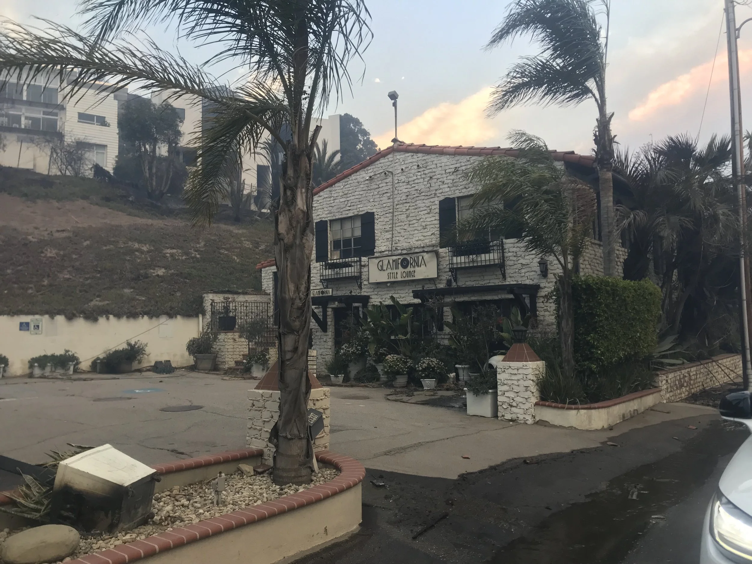
The Mobil station next to Dukes was the first of many mostly-untouched gas stations we saw all along and within the Forbidden Zone. Next to that, Dukes was unscathed. According to Brent and Kim Devane and others, the parking lot was used as a staging area for engines during the heat of the fire, and that’s what you want and need to protect your building.
DUKES TO BUNCE BAKES TO CRAWDADDY

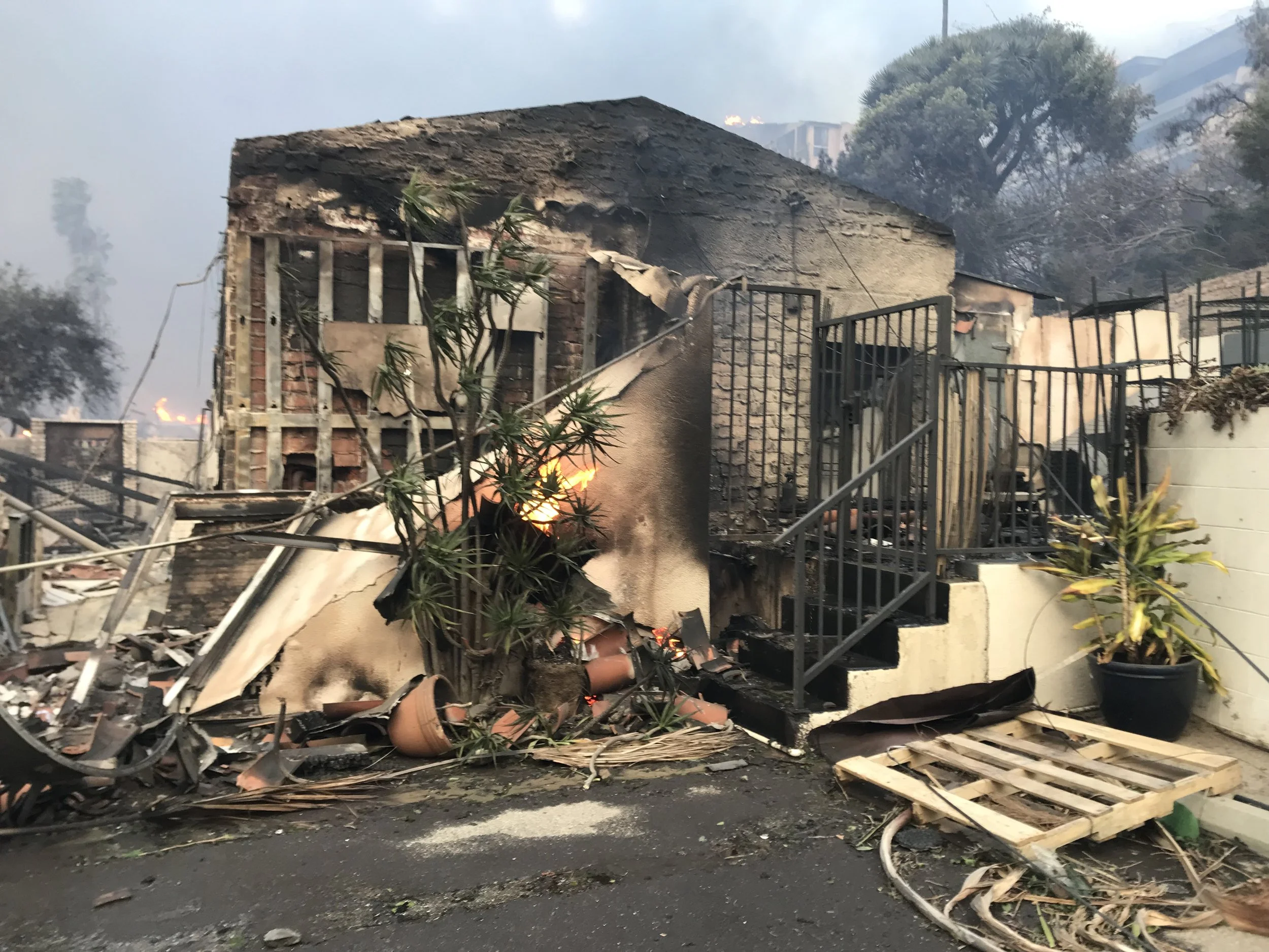
What’s left of Moonshadows. Imagine the heat it took to melt all those bottles, all that stainless steel kitchen equipment. Photo fromm https://recovery.lacounty.gov/palisades-fire/
More destroyed homes from 20630 to 20516 then the Maritime Rocks Access Way at Big Rock then about eight houses still standing that seem to have been shielded by a cliff across PCH. And along with the destroyed homes, there were a lot of vehicles in various states of melted, then nothing, then the adrenaline shock that was the parking lot for Moonshadows, and there isn’t even a shadow of that restaurant. Along the way there was lots of bent and twisted steel and when you understand that steel bends at 1000 degrees and melts at 2500 degrees, it’s easy to understand how any other material goes up in smoke and ash: “Like the snows of yesteryear, gone from this earth.”
FROM MOONSHADOWS TO BIG ROCK BEACH
Click to see the line of black and red icons along Big Rock Beach
After Moonshadows, according to the Palisades Fire Damage Map, a stunning 63 Destroyed structures all along Big Rock Beach and past Big Rock Drive to 19864 Pacific Coast Highway, where a row of houses marked as Black and Yellow are divided by a coastal access leading down to a thin strip of beach and some rocks.
This Saturday was a gloomy, gray day with rain predicted - two weeks too late - but the photos for the Palisades Fire Damage Map - were snapped by the DINS team on the clear blue January days that followed the Palisades Fire. Google Earth had damage overviews up very fast, but the street view photos went back to a clear, blue December day in 2023. The Damage Map and Google Streetview both show how sunny and nice Malibu can be in December and January, but they also revealed how scenic this stretch of coast is now that dozens and even hundreds of mid century apartments and 21st Century megamansions are no more.
CAN THE COUNTY, STATE, UNCLE SAM CONDEMN AND TAKE?

After the United States Supreme court declared Eminent Domain in 1923, construction of the Roosevelt Highway through Malibu took six years. The official opening was 1929. Mrs. Rindge wanted nothing to do with the highway or the Grand Opening, so they held the ceremony outside of the Rindge property at Sycamore Canyon. Models representing Canada and Mexico where there, along with dignitaries.
In 1923, May Rindge went up against Uncle Sam in the Supreme Court case Rindge Co, vs LA County. The argument against her was she was denying “access to beauty.” Uncle Sam declared Eminent Domain and forced The Roosevelt Highway through Mrs. Rindge’s private Idaho.
According to David Russell Wallace in the most excellent King and Queen of Malibu, the argument used to declare eminent domain over Mrs. Rindge’s private Idaho was not what you’d expect. Not interstate commerce but “access to beauty.”

There is an almost unspeakable amount of destruction along Pacific Coast Highway leading anyone with half an interest to wonder: How long will it take and what will it cost to remove all that debris?
Will an already sluggish and over-stressed Malibu Planning and Permitting bureaucracy be able to handle all these claims?
What will be allowed? What won’t?
Will all of those antiquated septic systems have to be replaced? What will that cost? '
How many property owners will not have the insurance and/or personal funds to rebuild?
Six years after Woolsey, some property owners are just getting started on rebuilding.
According to one local attorney who has lost a house and dealt with the aftermath:
You can’t write a story about how long it’s gonna take to rebuild from the Palisades fire without comparing it to the Woolsey Fire. Affluent communities, high education, high household income: Malibu and Palisades are gonna be very similar except the Palisades is going to be 10 times harder. The rebuild stats after the Woolsey Fire are sobering: I believe the total rebuild after six years is 38%. That’s for 700 homes in the City of Malibu and unincorporated areas. The Palisades Fire is 700 structures, so we’re looking at a minimum of 10 years.
I wrote a column about this for Malibu Times called Bu Back Better - https://malibutimes.com/malibu-seen-bu-back-better - where I said there is opportunity in destruction, and cited Windsor Castle after the Hall of Saint George Fire, Santa Cruz after the Loma Prieta earthquake and the fire at Notre Dame as examples of good things coming from disasters.
OPPORTUNITY FROM DISASTER: NOTRE DAME AND WINDSOR CASTLE.


CalTrans and others have plans to make Pacific Coast Highway kinder, gentler, slower and safer through Malibu. There are visualizations of roundabouts at Matador Beach and Webb Way, and another imagines PCH near the pier with a landscaped middle lane, sidewalks on both sides making it more pedestrian-friendly, and a protected bicycle lane.
What if that protected bicycle lane went all the way east and connected to Santa Monica = more fun, less traffic, less deaths.
CAL TRANS PLANS FOR A KINDLER, GENTLER PCH
The CalTrans vision for PCH through Malibu includes roundabouts at El Matador and Webb Way, and a landscaped median, sidewalks and a bike lane through the middle of town - from Cross Creek to how far east? Topanga?


If Malibu were to follow the example of Laguna Beach, the speed limit would be 35 MPH through most of Malibu, but 25 MPH beginning at Webb Way or Cross Creek, then 25 MPH past the pier and to the east, through all the business/residential areas and all the way to… Carbon Canyon? Big Rock? Topanga maybe?

The speed limit on South Coast Highway through the middle of Laguna Beach is 25 MPH. Which makes safe sense. Malibu’s 45 MPH speed limit through a business, recreation and residential district is no bueno, and has lead to more than 60 deaths and countless accidents and close calls. Slow it down to 25 MPH and surfers and beach-goers would not longer have to play Frogger with their lives.
The Palisades Fire razing PCH along Malibu has exposed the world to almost five miles of scenic beauty which citizens are going to get used to seeing over the next half decade plus. Is it possible that the County of Los Angeles or the State of California or Uncle Sam could pull some kind of “access to beauty” argument, declare Eminent Domain and condemn some of these properties - to allow visual access but also physical to a thin strip of very nice beach.
LOS ANGELES COUNTY BUYS NICHOLAS CANYON (ZEROS)
Karen Farrer reminded that the State of California did just that at Topanga in 1971 and Nicholas Canyon in 1973. According to Chat GPT:
“Nicholas Canyon in Malibu, often referred to locally as ‘Point Zero,’ became a public beach through a notable acquisition in the 1970s. The 23-acre site, located on the western Malibu coastline, was purchased by Los Angeles County in 1973 for $950,000 [2025$6,629,000.45].”
Los Angeles Beach History backs that up:
“Nicholas Canyon County Beach was the first beach acquired by the Department. The acquisition was made possible through a Federal Conservation Program Grant with $1.4 million in County matching funds [2025$9.769.053.29]. The beach was officially opened for public use July 1, 1973.”
THE COUNTY OF LOS ANGELES TAKES ZUMA BEACH
Going back farther than that: Zuma Beach was claimed by the County of Los Angeles when Mrs. Rindge couldn’t pay her taxes. According to Los Angeles Beach History:
“In December 1940 the entire Malibu Rindge property went up for sale under the pressure of tax assessments, legal bills and the collapse of the ranch with the Great Depression. May Rindge died 2 months later in February 1941. Within 6 years, over 80% of the Rindge holdings had been sold. Also in 1941, the Marblehead Land Company that May Rindge had created to lease and sell her land defaulted on Los Angeles County taxes due on Zuma Beach property. The County foreclosed on the property, demolished the few beach homes that were there and created a vast public parking lot. Popular Zuma Beach was born.”
LOS ANGELES COUNTY CONDEMNS TOPANGA BEACH
In the early 1907s, Los Angeles County condemned and bought Topanga Beach. If you ever want an accurate timeline of something, go to court cases - especially Supreme Court Cases.
The legalities at Topanga were summed up in Albright v. State of California (1979): https://law.justia.com/cases/california/court-of-appeal/3d/101/14.html
In February 1973 the state acquired property at Topanga Beach through condemnation proceedings. Prior thereto, the land in question was owned in fee by the Los Angeles Athletic Club. Starting in the early 1900's and continuing through early 1973, the club leased numerous parcels of the land to individuals who built houses thereon. The leases continued through early 1973.
After acquiring the Topanga Beach property in February 1973, the state started providing relocation assistance [$15,000 then, or about $104,668.43 now] to those homeowners who were moving out. Those who refused to move were issued termination notices in October 1973. In November 1973, the lessees filed suit in superior court to enjoin the state from evicting them. A temporary restraining order was issued but was dissolved in December 1973. '
In April 1975 the superior court enjoined all evictions because of the state's failure to comply with the Environmental Quality Act requirements. That injunction was dissolved on appeal by this court in May 1976. (Topanga Beach Renters Assn. v. Department of General Services (1976) 58 Cal. App. 3d 188 [129 Cal. Rptr. 739].) Meanwhile, in June 1975 the Department's Relocation Housing Appeals Board issued its decision against petitioners on certain issues of eligibility and increased benefits under the relocation act.
In December 1975 petitioners filed a petition for a writ of mandate and a complaint for declaratory relief against the state. Following the superior court's judgment, the Department appealed and petitioners cross-appealed.
So the condemnation of Topanga raged in court for at least two years and probably a lot more. If Uncle Sam and/or the State of California attempted to condemn parts of PCH through Malibu that had been burned and destroyed, how elaborate and expensive would those court cases be here in the litigious 21st Century?
Marshall Coben has lived in La Costa and the Malibu Colony and ran a film-shoot location business called Malibu Locations, so he knows every inch of this town. He has opinions on how the State should proceed:
“When I was born, my family lived on Charthouse Beach. All of that land as well as the land at Topanga belonged to the Los Angeles Athletic Club. They had plans to build a marina, etc. We moved because my dad could see the eminent domain coming. Our neighbors fought it for 10 years after we left and ultimately they lost and now we have camper vans where my family‘s house used to be.
I drove the Big Rock stretch today and It is a different drive now. Nothing but sky and ocean. It makes you realize how little land those houses actually had to build on. It’s just a tiny strip of dirt you can put a garage on and then hang a house on stilts over the tidal wet sand. If you look at what happened to Charthouse Beach where my family‘s house was in the 60’s, the ocean is demanding to take it back as it probably will soon between Topanga and Las Flores. Maybe the state should take this opportunity to let the insurance companies pay for the lost houses and then buy up the land as a long-term plan to acquire that entire stretch as mother nature continues to demand we leave it. I know that’s a hard position, but I think it’s harder to take the position that that is a viable stretch to put houses and bike lanes, etc.”
1923: UNCLE SAM CLAIMS A MALIBU RIGHT OF WAY THROUGH EMINENT DOMAIN
And then of course, going back to 1923, Uncle Sam declared Eminent Domain over the Rancho Malibu and forced the final leg of the Roosevelt Highway.
According to The King and Queen of Malibu:
“Two years after the Supreme Court decision, the county of Los Angeles issued May a check for $98,623 - slightly more than $1.3 million today - for the land it had claimed through eminent domain. She refused to cash it, unwilling to acknolwege the validity of the state’s claims to the end. Unknown to anyone outside the family, she desperately needed the money.”
So yes, the County of Los Angeles and the State of California and Uncle Sam can condemn and/or claim eminent domain over private property, and you have to wonder if that’s in the near future fate for large or small swaths of scorched land between Geffen Access and Topanga?
What is 4.5 miles of scenic beauty worth in land and property values?
We consulted the experts.
BUYING THE LOT, LOT BY LOT: THUS SPAKE GRUSKIN
There are people in and around Malibu who could conceivably buy all of it and turn a big chunk of PCH through Malibu into a beach park/dog walk/bike lane, scenic nudist colony or something, and wouldn’t that be nice?
Looking for answers, I consulted about 10 of the 3,245,901 realtors in Malibu with a hypothetical question: What would the average value of a Malibu lot along PCH be? - and got this answer from Mark Gruskin:
“Finding the average value of a Malibu lot on PCH is extremely difficult to quantify as each parcel and location is unique. A lot at Carbon Beach is worth a lot more than one down one by Topanga.
Plus, there have been very few land sales on the beach over the past five years to use as comps as most were developed and only a few remained to be sold. Only about a dozen or so sales in five years.
But throwing out the high and low sales and using all of the beach side sales in Malibu over the past five years the “ballpark average” is about $5,150,000 per lot.
Multiplying $5.150m x 400 = $2,060,000,000…so a bit over two billion sixty thousand if my rough math is correct. Hopefully, this gives you at least a very rough approximation of the value of just the dirt along that section of PCH.”
If there are 400 individual lots from Geffen Access to Topanga - and some of them aren’t owned but are on 100-year leases and not all of them are burned. But let’s say it would cost $2,000,000,000 to buy all the burned lots, clean away any sign of habitated humanity, make the beach accessible to divers, surfers, fishermen, beach-combers, dog walkers and dreamers and maybe put that bike path through along the top.
There are people in Malibu - who seem to love Malibu - who actually have the means to do something like this. People who have bought Hawaiians Islands for $500,000,000, or built luxury yachts for the same.
Anyone? Anyone?

TUNA CANYON TO TOPANGA: SPIRAL STAIRCASE TO NOWHERE
The spiral staircase to nowhere at 19014 PCH - as photographed and drawn, and compared - perhaps inappropriately - to the Hiroshima Peace Memorial. Illustration by Sara van Arsdale.
And then between the ironically=named Pena Canyon Road and Tuna Canyon Road, another 57 structures marked Red for Destroyed in that Disaster Map. The very last one of these is the burned steel structure with the now famous Spiral Staircase to Nowhere: 19014 Pacific Coast Highway. (Garrett at Zinque just said they should leave that S.S.T.N up as a monument, like the Hiroshima Peace Memorial (Genbaku Dome) - the only structure left standing after the nuclear attack on Hiroshima.)
TOPANGA = CHOLADA, WYLIES, REEL INN, RANCH MOTEL (RIP)

A couple more wrecked structures and a couple more standing structures and then the building on the ocean side with the blue wave up top that used to be the Boardrider’s Club was standing big and blue, untouched.
Across the way, RIP Cholada (2000 - 2025) - the Thai place that sounds like a Mexican restaurant and one of the places that people are mourning the most. Just east of that, hopefully Wylie’s Bait Shop (1946 - 2025) will rise from the ashes, then Rosenthal Winery (2005 - 2025) and the Reel Inn (1986 - 2025) = all beloved institutions.

For the whole story on the evolution of Oasis Imports and that space, go to: https://www.oasisimports.com/about-us.html
I always said if I ever won the lottery and bought a fancy house on Malibu Road I would go splurge on expensive, quality outdoor furniture at that place at the base of Topanga Canyon Road: On this day a scorched Buddha statue was about all that remained, and hopefully that will be the centerpiece of a reborn business. Oasis Imports (1982 - 2025) is listed as “temporarily closed” on Google Maps and let’s hope that’s true for all of these beloved institutions, including Feed Bin.


And also the Topanga Ranch Motel. Will this fire speed up or slow down the much-needed renovation of this historic property into places where locals and tourists can stay?
We shall see.
During this three hour tour on a gloomy Saturday, the lots where all those businesses once stood were a staging area for SoCal Edison and SoCal Gas and other service trucks, as they were working as hard as they could to restore services and return to normal.
Mastro’s looked unscathed and then with the The Building That is Not the Getty Villa off in the distance there is a long stretch that has always been open. There were a few RVs parked along there, and the remnants of others that didn’t - or couldn’t- flee during the fire.
Those RVs are not structures marked on the Palisades Fire Damage Map and some say they should have been as they seemed to be permanent residents of shoulder space along PCH going either way.
Driving along there were RVs still parked leading up to Mastros, but also scorched marks and piles of rubble for the RVs that couldn’t escape. If those RVs were/are a problem/eyesore/health hazard to you, that problem has been taken care of for a while.
VILLA DE LEON AND THE GETTY VILLA
A lot of people - including me - mistake the Villa de Leon for the Getty Villa, but the Getty Villa is farther back up in the hills. On the Damage Map the Villa de Leon is marked as Green for (Affected 1-9%). As seen from PCH, the Villa de Leon was standing tall, scorched all around its feet but nothing to the structure.
Further up the canyon, the real Getty Villa had a Black icon: Untouched.
On the other side of Villa de Leon, no bueno: A cluster of scorched homes along PCH were evidence of much more damage up above: A lot of Red and Green-marked houses in Castellamare, although some streets were untouched.
The Castellamare neighborhood from Villa de Leon to the east. Most of it torched. Image from Google Maps.
Brent said he had attempted to drive up into Castellamare on the first night of the fire, “But it was sketchy. Some switchbacks in there.” And he’s right, that would be a tight place to negotiate in a raging, fast-moving firestorm.
The pedestrian overpass at Castellamare was unscorched, as was Thelma Todd’s former building. If the Palisades Fire does inspire a rebuild of PCH through Malibu, pedestrian bridges at Surfrider Beach and Topanga and maybe up toward Zuma could be part of the equation.
FROM WILL ROGERS UP SUNSET, INTO THE FORBIDDEN ZONE.
From a staging area at Will Rogers, up Sunset Boulevard and into the Forbidden Zone. The wrecked zone. Palisades puts on an untarnished face at Sunset, but behind that = a world of Satanic wreckage.
Brent turned right on Sunset into the parking area for Will Rogers where more emergency and recovery vehicles were parked. He talked story a bit with other fire fighters, then turned left and entered a scene I can only describe like this: “This is what people must have felt like returning to Gaza, or Bakhmat, or New Orleans, or Pompei.”
In the parking lot at Will Rogers, looking into the valley of Sunset Boulevard with buildings on both sides, there was no sign of damage: “Behind those buildings there’s a big complex that burned. I thought all of this was going to burn with those winds. This is where I sat for a long time.”
Driving out of Will Rogers, Brent gave the timeline of how he got to drive a cool truck in a cool uniform and Obi Wan Kenobi his way through a disaster zone: “So I was a firefighter and started in San Diego all over but mostly in east county so like Fallbrook, Alpine and Descanso.. I did 22 years there and worked my way up from firefighter to engineer (driver) to Captain and then when I was promoted to Chief I joined Sacramento headquarters. Yeah it’s quite a bit of slides you have in your memory banks. When I do fire inspections I go back to ‘03 and ‘07 so here’s the code and here’s what your supposed to do and here’s what I would do if I had my family inside this house. You know what I mean? This gives you that kind of perspective.”

The main building of the Self Realization Center came out without a scratch, maybe because there’s an artificial lake full of water close by and/or because LA City Fire Dept Station 23 is 452 feet away (Can’t see it here). But some of the out buildings were not so lucky. Image from Google Maps.
Going up Sunset to the right there’s a Jack in the Box and a strip mall and a Subway that was burned. More and more houses on the way up and then somehow the Self Realization Center was unscathed. Past that there was a Sheriff’s Department blockade at Sunset and Palisades but Brent Jedied past that and kept going, deeper into the enormessnous of Pacific Palisades.
THE GOOD THE BAD AND THE UGLY OF SELF REALIZATION


WHERE THE STREETS BULLDOZE PANICKED CARS: PALISADES AND SUNSET
Going past the Sheriff’s and National Guard where Palisades Drive and Sunset meet, Brent pointed out a place that summed up the panic and chaos of the Palisades Fire: “This is where the sea of.. The parking lot was. I couldn’t comrphend it: ‘Am I in a parking lot now?’ And this is where the bulldozer came through and made that little line. I think they got jammed right here and people in the back started running. The fire ripped through this area. This is where I came to save those dogs.
The fire started around 10:30 and I got here around 1:00, I think.”
UP SUNSET INTO PALISADES
Driving up Sunset there was total destruction on all sides. You really do have to see to appreciate and be appalled by it. When describing what I saw to others I would say: “This is what Gazans must be seeing and feeling when they return home.” And also “It’s as if a drunk, mean, spiteful dragon was flying around, randomly fire-bombing.”
Or in a word, it’s Satanic. A powerful, evil, supernatural force destroyed most of a clean, prosperous city, displaced tens of thousands, killed some and caused 10 years and hundreds of billions of dollars in damages.
Driving on Sunset past Salerno - with destroyed houses on all side - Brent said: “This is the house right here. That was a red car. He said the house was super secure, good luck getting in. The dogs were barking but when I beat the door down they got scared and ran.”
MAN SAVES DOGS
If you follow Sunset past Salerno and Liverno using Street View on Google Maps, this is all the more heartbreaking. These are all tidy, prosperous, sunny, well-kept neighborhoods with houses clearly loved by their owners:
SALERNO AND SUNSET IN SUNNIER DAYS

Sunset and Salerno in May of 2024: Sunny, clean, happy. Photo from Google Maps.
Shining happy people, in beautiful houses, with beautiful dreams inside.
And now it’s all charred and gone. Hundreds of beloved houses. Thousands. It’s almost too much.
FIRE SCIENCE
On Sunset between Wildomar and North Almar, Brent gave some fire science: “There were houses on this street that were good, but when you looked the next street over they were nuked. There’s a little incline - do you see that? Fire runs downhill just like water would if you poured a pitcher. Look up this street: All the houses are good. See that incline? Fire is going anywhere but that street. See what I mean? If there’s a depression in the land two streets over it’s nuked.”
A TALE OF TWO CHURCHES
At the intersection of West Sunset Blvd and El Medio Avenue, the Palisades Lutheran Church was untouched, while directly across the street - maybe 150 feet away, all that was left of Palisades Presbyterian is a crumbling, two story structure holding up a cross.
You can read into that anything you want.
Palisades Lutheran and Palisades Presbyterian are about 150 feet apart from each other at the corner of Sunset and El Medio. One burned to the ground, the other not a scratch. Go figure.


PALISADES HIGH SCHOOL
Off to the right, Palisades High looked good from far but was far from good. Quite a few buildings damaged close to the playing field but the playing field looked untouched. And so it goes.
QUOTE FROM GR HERE ABOUT THE SCHOOL AND THE POOL
There were two National Guard in a heavy duty fighting vehicle blocking Temescal Canyon Road and most of the roads leading off Sunset into neighborhoods.
And then: Gelson’s looked like it was hit with A Shocking and Aweful, thousand-pound bomb. It’s destroyed. But the 76 Station a hundred feet away was open for business.
Photos from Google Earth and https://recovery.lacounty.gov/palisades-fire/
GELSONS GUTTED


CENTRAL PALISADES
The business district of Palisades was not quite as open. That complex to the right with Bank of America and Casa Nostra looked like Gelson’s: Like it had been aerial bombed with great vengeance and furious anger.
Turning left on North Swarthmore, Brent had a conversation with a female National Guardsman standing guard dwarfed by her vehicle: an M-ATV.
According to Wikipedia: “The Oshkosh M-ATV is a mine-resistant ambush protected (MRAP) vehicle developed by the Oshkosh Corporation for the MRAP All Terrain Vehicle (M-ATV) program. Intended to replace M1114 HMMWVs (Humvee), it is designed to provide the same levels of protection as the larger and heavier previous MRAPs, but with improved mobility.”
The Guardswoman said she was certified to drive it and while she felt safe inside of it, the vehicle is so big and high she is always worried about hitting something or someone. Brent said driving fire engines was the same and they both agreed it’s good to have passenger to serve as spotters.
GR is a retired firefighter who lost a rental house in the Palisades - next door to Kathy Kohner-Zuckerman - the original Gidget. GR spoke from experience and he wasn’t too keen on what he saw:
GR QUOTE TO COME TOMORROW
On the right the Palisades Village complex featuring an Yves Saint Laurent store was untouched. This complex is owned by billionaire and former Mayoral candidate Rick Caruso who was both condemned and praised for hiring private fire-fighters to protect his property.
The New York Times reported:
During the height of the fires, on Tuesday night into Wednesday morning, Rick Caruso, the billionaire developer who owns Palisades Village, was conferring with his security staff as they deployed several private firefighters from Arizona to save the shopping center (and who, Mr. Caruso said, tried unsuccessfully to save nearby homes as well).
Early Wednesday morning, after fire hydrants in the area went dry or lost pressure, Mr. Caruso called in private water trucks to assist.
“Our property is standing,” Mr. Caruso, who ran for mayor of Los Angeles in 2022 and lost to Karen Bass, said in an interview on Wednesday. “Everything around us is gone. It is like a war zone.”
Again the argument about whether hiring private firefighters is elitist, or does it free up resources for others?
And Mr. Caruso was correct about the war zone. While some buildings on North Swarthmore were destroyed and some unscathed, behind that, hundreds of homes in the skull-shaped “Alphabet neighborhood” bordered by Chautauqua and Sunset were almost entirely marked Red on the Palisades Fire Damage Map.'
Hundreds of houses. Entire neighborhoods gone.
HOW DO BANKS PROTECT MONEY AND VALUABLES IN A FIRE?
Up North Swarthmore, the Bay Theater looked okay, while other buildings were scorched - some not. The end of North Swarthmore was yellow taped and blocked, but beyond there was a glimpse of the devastation that had fallen on the Alphabet Neighborhood.
Turned around, turned left at the M-ATV onto Sunset, which like everywhere else, was lined with buildings half scorched, half not.
ANAWALTS IS AOK, MOSTLY

Bags of Sakrete lumped outside of Anawalts, either melted by the fire or hardened by water or both. Photo from https://recovery.lacounty.gov/palisades-fire/
The Chase Bank looked like it had been bombed, leading one to wonder: What do they do with the money and valuables? Back in Malibu a few days later a POW said they had two safe deposit boxes in that bank, but had no communication on the state of what was in them.
Berkshire Hathaway Home Services was destroyed, and then from outside, it looked like Anawalt’s Palisades got some damage but it was was marked Green for (Affected 1-9%).
Less than 100 feet away, Ralphs was Red, as was Corpus Christi Elementary and then in all directions - a tsunami of Red.
Moving out of the Anawalt’s parking lot, turned right onto Sunset lined with burned buildings on both sides until Fire Station 69 at the corner of Carey.
THE ALPHABET NEIGHBORHOODS

Turned left on Drummond then left on Galloway into the Alphabet Streets- a skull-shaped group of neighborhoods that is 2.69 miles in perimeter according to Google Earth - which also has recent fire damage photos as of 1-30-2025 - and .44 square miles in area, if that makes sense.
Looking at these streets on Google Earth, this was a shining, happy, sunny, clean, prosperous neighborhood.
STILL STANDING: GALLOWAY, WHITE TBIRD, CHARM ACRES ALBRIGHT 1946
This video is huge even downsized. I’ll try again tomorrow/Friday
But we dove through Armageddon. It’s not possible to overstate how throughly devastated all of this is. In one driveway there was a classic white T-Bird sitting unblackened and you have to wonder if it came through the fire looking that clean. Unlikely but it shone out like a pristine beacon amid devastation.
1167 GALLOWAY: THE UNTOUCHED


On Galloway going backward through the Alphabet Streets: Carey and Bashford and Albright and then in the midst of all the burned trees and standing chimneys: 1167 Galloway. Unblemished and cheery, shining and happy when there’s nothing standing around it for a quarter mile or more in any direction.
1167 Galloway is marked Green for “Affected 1-9%) and the three photos with it show some scorched railing and porches. (The song I Am a Rock I Am an Island is playing as I write this) Zillow values this house at almost $4,000,000 and you have to wonder if the value of it goes up or down because it’s surrounded by rubble.
CHARRED ACRES PLACE

Turned left on Bestor. An untouched house at 15291 Bestor, a place that was a dirt lot and under construction in December 2023, according to Google Maps. Now listed at $7,500,000 on Zillow. Still standing.

1141 Via de la Paz, Pacific Palisades. Gotta wonder how many nice cars were destroyed in this fire. How many Teslas and others with sketchy, toxic ingredients? Photo from https://recovery.lacounty.gov/palisades-fire/
Turned onto Via de la Paz, went by 1141 with a burned BMW in the driveway then turned left onto Charmed Acres Place. A glib smartass would call it Charred Acres, but let’s not, because this place was as charred as everything around it from the mountains to the sea.
And then, three buildings that were charmed. Unscorched, with tree ornaments somehow blowing in the wind.
1134 CHARM ACRES PLACE
1134 Charm Acres Place is one of three houses that came through the Palisades Fire untouched. With hanging ball decorations still swinging from the trees.


“What do you think saved them?” I asked.
“The material they used,” Brent said. “This is all concrete walls.”
And then on the corner of Charm Acres and Albright, a decidedly old-school house also untouched, with maybe a couple of broken windows. A house built in 1946 listing on Zillow at almost $3,000,000
1101 CHARM ACRES PLACE AND ALBRIGHT, BUILT IN 1946.


Turned right on Albright where things were not all right. All that devastation on both sides were multi-story apartment buildings up until January 8, and now it’s smoke and ash and a couple dozen other displaced citizens.
Turning left onto Via de la Paz, more devastation until the corner of Via de la Paz and Sunset, where the Department of Water and Power building was sitting pretty, and there was a National Guardsman with a MAT-V watching over it all.
Apparently there was enough power in the water to protect this place, but that water power was and still is a very hot topic among a lot of people who are white hot about this fire.

The Shell Station at the corner was badly burned and listed as Destroyed. Down Sunset, past El Medio and the burned Presbyterian and the unburned Lutheran. Go figure.
A quick glance up Muskingum exposed some destroyed houses. According to the damage map, the first seven houses on the west side of Muskingum were Destroyed, but most of the rest of that neighborhood was somehow saved.
Random, dude.

PALISADES HIGHLANDS
I’d never been up Palisades Highlands but passed the intersection of that and Sunset many times. This time we went up Palisades Highlands to see what we could see.
Down Sunset from Marquez/Baylor talking about Point Dume. Lots of torched houses a few still standing.
Must have paused it when we turned up Palisades went on back streets Avenida Santa Ynez and Avenida Cortez
One burned house on Avenida de Santa Ynez. But mostly untouched.
THE INFAMOUS AND EMPTY SANTA YNEZ RESERVOIR
Driving up Palisades Drive into terrain that is steep and loaded with fuel and a reminder of how difficult it would be to completely denude these mountains of fuel, whether with goats or controlled burns or Direct Energy Weapons or Jewish Space Lasers or any technique.
Turned left off Palisades Circle to Palisades Drive. Mostly untouched then one very destroyed apartment complex to the right.
PALISADES HIGHLANDS, SANTA YNEZ RESERVOIR AND THE WRECKED APARTMENTS
It looked like there was a reservoir off to the west and indeed after getting home and poking around saw that was the now-infamous Santa Ynez Reservoir, which did not have a drop of the 117,000,000 gallons of water it was capable of containing.


The LA Times detailed it all in This reservoir was built to save Pacific Palisades. It was empty when the flames came
An excerpt:
That the 117-million-gallon reservoir was off line for repairs sparked outrage against the DWP and its leadership, prompting at least two lawsuits and spurring Gov. Gavin Newsom to order an investigation. Los Angeles Mayor Karen Bass has also promised a complete assessment of the city’s response to the wildfire, which has destroyed at least 6,380 structures and killed at least 11 people.
Former and current DWP officials acknowledge that if the reservoir had held water, higher-elevation areas of the Palisades would have had more water pressure, but it’s unclear for how long.
The reservoir remains empty, and the DWP’s chief of water operations told The Times that the repairs will not be done until April or May.
The episode has drawn an urgent question from residents and city leaders: Why was the reservoir empty for nearly a year?
The saga traces back to January 2024, when a DWP property manager spotted a tear in the reservoir’s floating cover after a series of rainstorms, according to internal emails reviewed by The Times.
For decades, the reservoir sat uncovered until the city in 2012 installed a large floating membrane to comply with federal regulations. The cover is meant to prevent animals and debris from contaminating the water and to limit algae and bacteria.
Directly east of the empty reservoir, The Lower Woodies was a complex of 20 million-dollar townhomes that burned to the ground. Those images were already up on Google Maps. It was all about 1000 feet from the empty reservoir, and you have to wonder if the hundreds of units and many hundreds of displaced people would have been saved that inconvenience if some or all of that 117,000,000 gallons would have been made available.
As Kanye West said: “I guess we’ll never know.”
But I still say, you could have dumped all 117,000,000 gallons of water in Santa Ynez Reservoir and every gallon of water in Los Angeles County on that fire and it would not have made much difference.
When you see how much destruction that fire caused through Palisades - and seven mile over hills and dales and down valleys to the beach and all the way to Geffen’s house - you know that fire was not beatable or quenchable.
No more than you could stop a tsunami or a hurricane or a tornado or an earthquake.
PALISADES TO SUNSET - DOUBLE TIME
Down Palisades to Sunset, turned right. More scorched houses, past the fire station. Down to the water. Apartments not burned.
Turned right from Sunset onto PCH, now going back from whence we came, looking at the damage going east to west - different angle on a lot to see: men and machines, scorched houses, scenic vistas out to sea that humans haven’t seen for decades. Even on a gloomy day - beguiling.
BIG ROCK


I had promised H Conrad we would go up Las Flores to check out the school she founded: Sycamore School. The night of the fire she told me to go to Station 88 and alert the fire fighters they could stage there nd fight whatever was coming.
I rang the buzzer at 88, but they all had a glazed look and weren’t interested: “We’re heading out now.”
Sycamore School is just under a mile up Las Flores Road, in a tight valley at the bottom of a ridge with the Big Rock neighborhood on the other side. We didn’t go up Big Rock, but it was common knowledge that Big Rock had taken the brunt of the fire.
Driving east to west on PCH, past the Villa de Leon and the roadblock at Coastline then past and making the sign of the cross for Oasis Imports, the Feed Bin, Topanga Ranch Motel, Reel Inn, Wylie’s, Rosenthal Winery and Cholada Thai - gone, all gone.
The world is gonna be shocked when they pass by such beloved, familiar landmarks that are no more.
For more information on the petition: https://www.change.org/p/petition-to-protect-topanga-and-la-county-from-toxic-waste-sorting-site?source_location=tag_
(And now there is a big controversy and a petition about using the area behind the Topanga Ranch Motel as a staging area for debris removal from along PCH and up Big Rock and Carbon Canyon and all over. Objectors say it’s too close to the lagoon and isn’t there a better location?)
There will be a different and more pleasant shock when driving east to west and enjoying all the access to scenic beauty. PCH is now a snaggle-toothed road: A few teeth but larger gaps.
Still gloomy on this Saturday January 25 but the world is going to get an eyeful looking west on a blue-sky day. It’s gonna be beautiful for a long long time, if not forever.
As Steve Woods described it a week before: “I just drove the entire stretch of PCH down to Santa Monica and back yesterday (Saturday Jan. 18) with an infrastructure contractor who waved us by the barricades. And aside from the mind-boggling, surreal devastation, I was lost. I literally did not know where I was because all the recognizable landmark houses were gone. But for the first time, I saw an incredible ocean view that I had never seen before: the actual Big Rock Point is a beautiful geologic marine feature that has been visually obstructed by homes with antiquated septic systems leaching into the ocean.”
A MILE OR SO OF SCENIC BEAUTY: VILLA DE LEON, TOPANGA, BIG ROCK
BUNCE BAKES > LAS FLORES > MALIBU TIMES BLDG > FLAG MAN 3x
Look at a terrain map of the Santa Monica Mountains and it’s frightening that a fire that started at the Skull Trailhead could travel 6.24 miles as the crow flies and a lot more over hill and dale and burn all the way to Las Flores Canyon.
(Tomorrow I’m going to look at the After Action Report for the PAlisades Fire for numbers like: When the 911 call was received, when the first engines or aircraft were on the scene, and how the fire progressed in relation to time. At what time did it reach Las Flores Canyon)
A Malibu City Council Member Who Shall Not Be Named wanted us to take a look at the school he/she founded in ???: Sycamore School. Turning right into Las Flores Canyon, the apartment building at the base of
Passed the former international Engine on left.Looks like Malibu Times building burned.
To orange sign guy.
LAS FLORES CREEK AND PCH 1912 TO NOW
Las Flores Creek was the eastern boundary of the 13,300 acre Rancho Malibu. Open and unguarded through the 19th Century, into the 20th, the Rindge put up fences, then locked gates, then cowboys with sidearms to defend those gates and keep people out. Mrs Rindge was worried about arsonists, rustlers, hustlers and squatters. By 1915, the Las Flores Inn was open for business just outside the gates. Visitors rode horses then cars to the eastern gate and must have thought: “One woman owns all of that. Everything beyond that gate, all the way to Point Dume, and just as much after - all the way to Ventura County Line!”


Headed west on PCH, seeing things we’d never seen, passed the former international headquarters of Bunce Bakes and again felt bad for a young woman who is lovely inside and out, who worked hard through school to become a coder, was working double hard to establish her tasty snack business and then it all went up in smoke and ash.
One of thousands of unfortunate stories in the wake of the Palisades Fire.
This is Alison and her friend Rachel doing the Betty and Veronica thing to make a promotional video for Bunce Bakes.
Went past Bunce Bakes International, some places still standing, some places nuked and then turned right on Las Flores Canyon Road. This was the eastern boundary of the Rancho Malibu Topanga y Sequit for many years - protected by signs, locked gates and rascals with guns.

Near the bottom of Las Flores Canyon, the Malibuan Apartments made it, while the former headquarters of Malibu Times did not. Photo from Google Earth.
Going up Las Flores, the Malibuan Apartments - home to Viking Dave and Post Office Maria- were still standing and that was good, because I had helped the owner line the walls and halls with Malibu historic photos and that would have been yet another shame and a waste.
Left next door, the former headquarters for Malibu Times was down in smoke and ash. Some homes were intact, others were burned.
SYCAMORE AND UNDER THE OAKS SCHOOLS
Opening private schools is one thing POWA/OA (People Of Wealth And/Or Accomplishment) enjoy these days: Jeff Bezos, Kanye West, Mark Zuckerberg, Elon Musk and Andre Agassi are among the accomplished people who have founded private school offering focused, specialized instruction to small groups of students.
According to Chat GPT: The Sycamore School is a private, nonsectarian institution located at 3504 Las Flores Canyon Road in Malibu, California. Serving students from Transitional Kindergarten through 5th grade, the school emphasizes developing self-directed learners and creative problem solvers equipped to thrive in a complex and evolving world.
Educational Approach:
The Sycamore School's curriculum is designed to be engaging, continuous, and future-focused. Learning is playful, relevant, project-based, and challenging, fostering active, intrinsically motivated learners who feel autonomous and empowered. The school aims to equip students with skills such as teamwork, critical thinking, and self-direction to navigate a dynamic world.
Community and Enrollment:
Situated in Las Flores Canyon, the school attracts families from across Los Angeles. With a student-teacher ratio of 5:1, it offers a personalized learning environment. The student body comprises approximately 42 students, with about 11% representing minority groups.

Haylynn Conrad was one of the founders of Sycamore School and wanted us to cruise by and shoot photos and video of what was damaged and what was not. Somehow, this school located in the middle of a raging firestorm up against torched cliffs in a tight valley did not burn - with the exception of some playground equipment.
I had put an idea in Haylynn’s ear about Malibu creating a Chumash-inspired children’s playground with dolphins and tomol canoes and dome-shaped ‘ap play structures and maybe a finger painting wall.
She might do that when the playground is rebuilt.
I thought I had dreamed up an original idea but such a Chumash-themed playground already exists in Carpinteria.
Oh well, at least they'll understand the mission if Sycamore School orders one of their own.
https://www.carpmorningrotary.org/stories/tomol-interpretive-play-area
A MESSAGE OF LOVE FROM OAKS PRE SCHOOL


A spitwad shot away, Sunshine Armstrong’s Under the Oaks Pre School - another school named for a tree at the bottom of a tight valley in the middle of a firestorm - was also unscathed. A good thing, because the Armstrongs are good people.
One of the many stories coming from the Palisades Fire was Sunshine’s heroic bicycle ride past the roadblock on the east end of PCH and all the way to Latigo to comfort her frightened daughter. That would have been a wild ride.
I suggested perhaps the untorched school was some pre-karma for Haylynn, who a couple days later wrangled a healthy $750,000 for the Malibu Community Brigade, another $750,000 for LACO Sheriff Jennifer Seetoo and another $250,000 for a crime and fire prevention drone program being established by the Sheriff’s Department.
But she fouled that idea off with a shot of reality: "No I don’t own the school. I donated it to the school's non-profit so it has nothing to do with my karma. The school is closing its doors after almost 10 years. So there’s no luck there. I make no penny. I only spend money.
And the truth is, the school was saved by a cheap sprinkler system that was installed by a friend. And turned on the night of by a friend. It’s good to have friends. Luck and karma not included.
You can’t find the story online as it wasn’t published but the founding families who were there the first year with me know it. I’m hosting one family after their home burned. These are some of my oldest dearest friends in malibu. Mostly from Big Rock.
And because it’s closing its doors after almost ten years the story should be told."
Stay tuned for that.
PAST THE COURTHOUSE AND STATION 70 TO CARBON(IZED) CANYON
Back down LAs Flores Canyon, turning west on PCH, looking at Carbon Beach on the inland side: Quite a few burned houses, except for the house with the weird roof I always called The Beetlejuice House.
Courhouse was unsinge, Cliff Diver building and the one next door. Looked for familiar landmarks then turned up Carbon Canyon Road. There is a grainy, low-res video of a house on fire being hosed down directly across from Station 70 - so proximity doesn’t always matter.
ACROSS FROM STATION 70 WHERE PCH MEETS CARBON CANYON
Couldn’t find what time this was shot but didn’t think the fire burned all the way to Carbon Canyon in the day time.
It’s Sunday February 2 and today going to drive just-opened PCH in a Ford Lightning, and stop by Zuma Jays to look at the official fire reports.
Curious to see a timeline of when the fire started, when the first responders got there, and how it spread.
CHEZ TOM

Tom’s house, is a very very fine house and it’s great that it didn’t burn to the ground. Photo from Palisades Disaster Map.
About a week or so before the Palisades Fire, I saw Tom at Sparky’s Pizza. We talked about the Franklin Fire and about fires in general. His house is up Carbon pretty close to Station 70 and he felt that proximity gave him some security. Looks like he was correct. Yay Tom.
CARBON CANYON DAMAGE MAP

Years ago I hung out with an actor named Adam Nelson who was one of the Savage Brothers in Mystic River, and also played a particularly disturbing psycho on Criminal Minds. For a while he lived on the burned out property of Sean P - another actor. This is where Sean P lived with a singer known as M.
That place burned in the 1993 Topanga Fire and was never rebuilt. I went up there a couple of times and remember the basement to a house and a pool and that was it. The rest burned up in one of many many Malibu brushfires.

On the way in and out driving past I remembered that somewhat medieval, curved wrought iron fence and pointed it out to Brent: “That’s the fence you have when you hate paparazzi and live with M.”
THIS IS THE FENCE YOU HAVE WHEN YOU ARE MARRIED TO M
Trevor A also lost his house and beloved Airstream somewhere on Carbon Canyon and again: That’s just God, or nature, or the fates or whoever being mean. Trevor A is a cool dude who worked in Hollywood for a while and now just paints and raises troublesome daughters. One of whom looks Irish but swears she isn’t. Whatever.
NUMBER$$$$: CALIFORNIA INSURANCE AND FAIR PLAN
The Palisades Fire generated a lot of numbers in the minds of citizens:
What time did the fire break out?
When was the first 911 call?
When were the first engines/aircraft on scene?
How many houses were destroyed in Palisades?
How many fire fighters, engines, water trucks, helicopters, Super Scoopers were involved?
What did all of that cost?
What did it cost to keep thousands of fire-fighters at Zuma, Will Rogers and Chili Cookoff between the Palisades Fire and the Hughes Fire?
How long will it take and what will be the total cost to remove all that debris?
What is the average value of a house on the ocean side of PCH between Geffen Access and Topanga?
How long will it take to get plans approved to rebuild along PCH, in Big Rock, in Carbon Canyon, Las Flores Canyon and every corner of Pacific Palisades?
And how do insurance companies survive covering this kind of calamity?
While working on this project I set aside a book I am working on with Marc Andreini, a surfboard shaper who has been involved in the insurance industry for decades,.
He emailed me these two documents about why major insurance companies are finding it bad business to do business in California, and how exposed the California FAIR Plan is.
FAIR PLAN, ALL STATE, STATE FARM, ETC.


PITCHFORKS AND LANTERNS AT THE MALIBU TOWN HALL
At the end of a long day of charred destruction and sad stories, the city of Malibu had a Town Hall at Malibu High. Not sure what the capacity of the Arlene and Dick van Dyke Theater is, but it was Standing Room Not Allowed with anyone not seated shunted off to the overflow in the library.
Up on the stage there was an alphabet soup of agencies: FEMA, EPA, LASD, ACE, LACOFD.
After a long day of driving and trying to process all that I saw we went from zingate to the town hall meeting at Malibu high.I don't know what the capacity of that Dick Van Dyke theater is but it was fall and the overflow was in the library.it was pitch forks. And lanterns. People angry and frustrated by the fire and the recovery.up on the stage was an alphabet soup of e. PA Ace fema. And the other agencies tasked with recovery
MRCA was not there and that's probably a good thing. Cause it might have been torn asunder. By a crowd who loudly booed. Every time those letters came up.people blame the. MRCA for a lack of breast cruelights. Which might have contributed to this fire.Scott Dietrich brought app brush eating goats, and he is correct.a friend in Watson will use to keep them. And there is effective as a plague of locusts.I've seen them go through 10 feet deep in 4 foot high stands of poison, oak black berry and not leave a shred of green.but does anyone really think all the heels of Santa Monica can be cleared of brush? Unlikely period